
Find the suitable RV PARK | RV Camping nearby or you want.
Daniel Boone National Forest


Address: 5195 Kentucky 801 South,Morehead,KY 40351
https://www.fs.usda.gov/recarea/dbnf/recreation/hunting/recarea/?recid=39324&actid=29 Tel: 606-780-7818
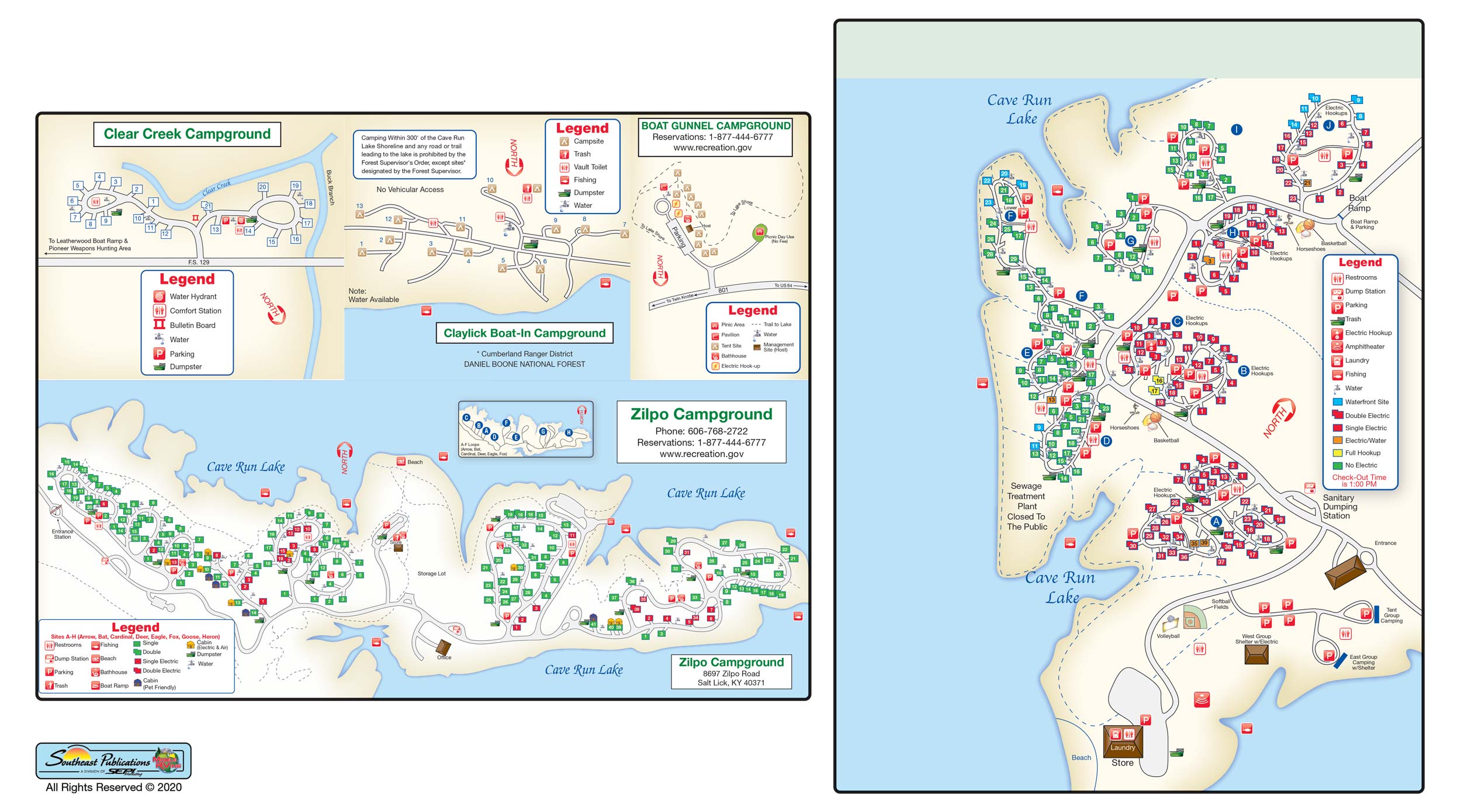
Daniel Boone National Forest Site Layout

Location Description: The Daniel Boone National Forest features four ranger districts: Cumberland, London, Stearns and Redbird. The district ranger and the staff is your first point of contact with the Forest Service. They are your best source of specific information about trails and campgrounds. All office addresses and phone numbers can be found on the Offices page.,These areas are intermingled with private and state land across 21 counties of eastern Kentucky. The forest headquarters, referred to as the Supervisor's Office, is located in Winchester, Kentucky.,In February 1937 a national forest for Kentucky was officially established under a proclamation signed by President Franklin D. Roosevelt. Originally named the Cumberland National Forest, the forest was renamed in 1966 as the Daniel Boone National Forest in recognition of the adventurous frontiersman that explored much of this Kentucky region.,The Daniel Boone National Forest is among 155 national forests, 20 national grasslands and other public land utilizations totaling 193 million acres in 44 states, Puerto Rico and the Virgin Islands. The national forest system is managed by the Forest Service under the jurisdiction of the United States Department of Agriculture (USDA). The Forest Service was established in 1905 for the conservation management of natural resources and to provide our nation with a sustained yield of forest products for future use.,Map of Ranger Districts on the Daniel Boone,The forest is managed for multiple uses, including recreation, timber, wildlife, fish, water, minerals and wilderness. The diverse landscape of the forest provides a home for thousands of plant and animal species, including species that are federally listed as threatened or endangered.,Lands and Acquisitions: Our land adjustment programs allow the Forest Service to acquire lands for the purpose of consolidating national forest system lands and to benefit resource management programs.,Forest Boundaries: Learn how to recognize when you are on national forest land.,Forest Ownership Pattern: Shows the pattern of ownership between national forest land and private land within the proclamation boundary.,Counties with National Forest lands: Map of Kentucky showing the counties that contain national forest lands.
Membership: Passport America, Thousand Trails
Credit Cards Accepted:


Seaasons open data: No Information Available
office hours: No Information Available
Amenities
Local Area Attractions
- Cave Run Storytelling (September Area Event)
- Morehead Peddlers Mall
- Mountain View Drive-In
- Red River Gorge
- Red River Adventure


